

Antique Map of Ireland, Herman Moll 1723
Herman Moll (1654–1732)
From The Compleat Geographer: or, The Chorography and Topography of all the Known Parts of the Earth (4th edition, London: J. Knapton, 1723)
Engraving on laid paper, 21.59 × 34.29 cm
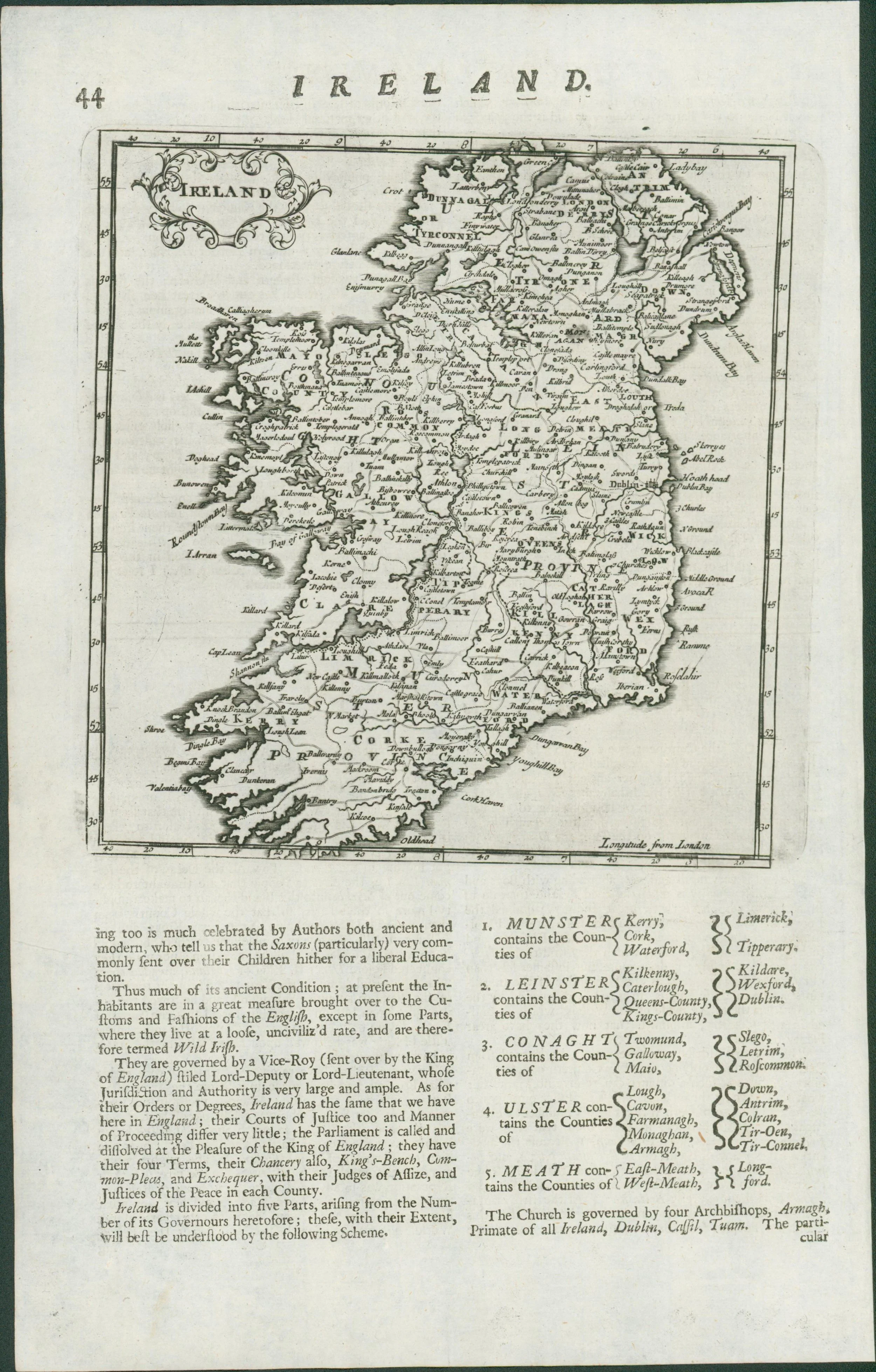
This is quite a large double-sided leaf featuring, on recto, a detailed description of Ireland under the bold heading IRELAND. The text provides a geographic, cultural, and political overview of the island, including observations on climate, soil, and social character, with eighteenth-century perceptions of Irish inhabitants. On verso, page 44, appears Moll’s engraved map titled Ireland, with a decorative cartouche and engraved border, showing the island divided into the provinces of Munster, Leinster, Connaught, and Ulster, with a county index below.
Cartographic Note:
Moll’s map is a compact but accurate outline of Ireland, typical of his pragmatic style: clear lettering, minimal ornament, and functional borders. This practical aesthetic made his maps especially popular with merchants, travellers, and readers of geographical compendia.
Context & Maker:
Herman Moll was a Dutch-born cartographer active in London, known for his bold geographic claims (famously declaring “California is an Island”). His circle included Robert Boyle, William Dampier, and Robert Hooke, and his works were widely collected by scholars and merchants alike. The Compleat Geographer was one of his most accessible works, intended as a broad compendium of world geography.
This map describes the “Wild Irish”, a Tudor/Elizabethan phrase, carried into the 17th and 18th centuries, to distinguish Gaelic, Catholic, or rural Irish from the “civil” English settlers in towns and garrisons. Sixteenth-century English narratives mostly characterised the Irish people as ‘wild’, barbaric and uncivilised.
It implied barbarity, lawlessness, and cultural inferiority, justifying conquest, confiscation, and attempts at anglicisation.
Condition Report:
Very good to excellent impression with crisp text and clear platemark. Expected faint show-through from verso, minor marginal handling, but overall unusually well-preserved for nearly 300 years.
This impression shows a slight tilt of the plate on the sheet, a normal feature of hand-press printing in the early 18th century. Such quirks underline the authenticity of Moll’s work, reminding us each map was individually pulled by hand.
Dimensions: ~8 ½ × 13 ½ in. (sheet)
Rarity and Collectability:
While Moll’s larger atlas maps (such as those from The World Described) are more widely collected, leaves from The Compleat Geographer remain comparatively scarce on the market due to the smaller print run of later editions. Complete 1723 editions appear irregularly at auction; individual leaves with map and facing text are increasingly sought by collectors of Irish cartography.
This is the map that shows off all of the
Herman Moll (1654–1732)
From The Compleat Geographer: or, The Chorography and Topography of all the Known Parts of the Earth (4th edition, London: J. Knapton, 1723)
Engraving on laid paper, 21.59 × 34.29 cm
This is quite a large double-sided leaf featuring, on recto, a detailed description of Ireland under the bold heading IRELAND. The text provides a geographic, cultural, and political overview of the island, including observations on climate, soil, and social character, with eighteenth-century perceptions of Irish inhabitants. On verso, page 44, appears Moll’s engraved map titled Ireland, with a decorative cartouche and engraved border, showing the island divided into the provinces of Munster, Leinster, Connaught, and Ulster, with a county index below.
Cartographic Note:
Moll’s map is a compact but accurate outline of Ireland, typical of his pragmatic style: clear lettering, minimal ornament, and functional borders. This practical aesthetic made his maps especially popular with merchants, travellers, and readers of geographical compendia.
Context & Maker:
Herman Moll was a Dutch-born cartographer active in London, known for his bold geographic claims (famously declaring “California is an Island”). His circle included Robert Boyle, William Dampier, and Robert Hooke, and his works were widely collected by scholars and merchants alike. The Compleat Geographer was one of his most accessible works, intended as a broad compendium of world geography.
This map describes the “Wild Irish”, a Tudor/Elizabethan phrase, carried into the 17th and 18th centuries, to distinguish Gaelic, Catholic, or rural Irish from the “civil” English settlers in towns and garrisons. Sixteenth-century English narratives mostly characterised the Irish people as ‘wild’, barbaric and uncivilised.
It implied barbarity, lawlessness, and cultural inferiority, justifying conquest, confiscation, and attempts at anglicisation.
Condition Report:
Very good to excellent impression with crisp text and clear platemark. Expected faint show-through from verso, minor marginal handling, but overall unusually well-preserved for nearly 300 years.
This impression shows a slight tilt of the plate on the sheet, a normal feature of hand-press printing in the early 18th century. Such quirks underline the authenticity of Moll’s work, reminding us each map was individually pulled by hand.
Dimensions: ~8 ½ × 13 ½ in. (sheet)
Rarity and Collectability:
While Moll’s larger atlas maps (such as those from The World Described) are more widely collected, leaves from The Compleat Geographer remain comparatively scarce on the market due to the smaller print run of later editions. Complete 1723 editions appear irregularly at auction; individual leaves with map and facing text are increasingly sought by collectors of Irish cartography.
This is the map that shows off all of the